Stop
1: Reykanestá and Stampar (Submarine
and terrestrial eruptions, feeder dike, base surge)
Start from the international
Airport
at Keflavik and takr the road no. 44 to the south heading to Hafnir.
Head
directly south on road no. 425 through Hafnir and to the salt factory
at
Reykjanes and follow the signs to Reykjanesviti (the lighthouse at
Reykjanes).
The Reykjanes ridge comes at shore at the tip of the Reykjanes
peninsula. The geology is characterized by recent lava flows and open
tensional fissures. At this place we are in the central part of the
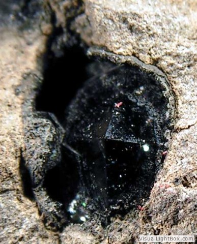
Reykjanes fissure swarm. At the shore we find remnants of a phreatic
crater from the year 1226 which formed the Medieval tephra layer. Part
of the crater has been overrun by lava flows from the same eruption. In
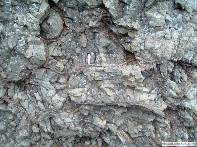
a small cliff a feeder dike is exposed that can be traced to a spatter
cone formed in that year.
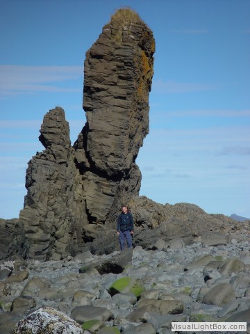
Nice pillow lava can be seen at Bæjarfell, where the present
lighthouse stands, and Valahnúkur, where the foundations of
the old lighthouse can still be seen. The pillow lava belongs
to a sequence of steep móberg hill composed of pillow lava
and hydroclastic tephra and breccia.
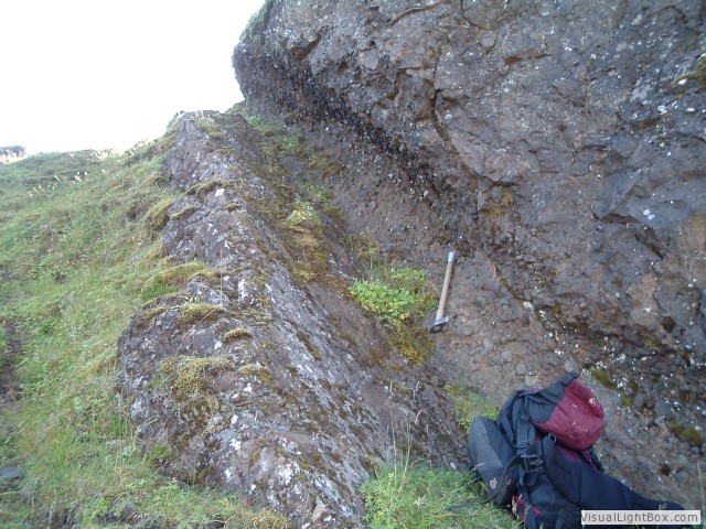
Vatnsfell is a rather inconspicuous rise on the coast north
Valahnúkur, but is worth a visit for a closer look at the
internal make-up of tuff cones. It is made up of lapilli tuff deposits,
which are the remnants of two tuff cones formed by submarine explosive
eruptions in the early stages of the Reykjanes Fires in about 1210. The
internal structures of theses cone are best exposed in otcrops apposite
Karl, the sea stack rising, about 300 m off shore. Theolder cone,which
makes up the bulk of Vatnsfell proper, was 30 m high and 650 m wide,
with the crater located 100 m off shore. The lower part of the older
tuff cone consiss of wavy to cross-bedded ash deposits formed by
repeated base surges, whereas the upper part consists of coarser-grain
lapilli tuff composed of alternating base surges and tephra fall units.
On either sides of Vatnsfell, the older cone is capped and flanked by
the deposits from the younger one, consists of fine-grain lapilli tuff
with repeated pairs of base-surge and tephra-fall layers. Many impact
craters formed by ballistic blocks ejected from the crater during the
eruptions commonly disrupt bedding in both cones.
|
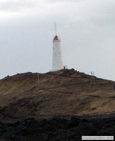
Reykanesviti
(lighthouse)
Pillow lava at Valahnúkur
|
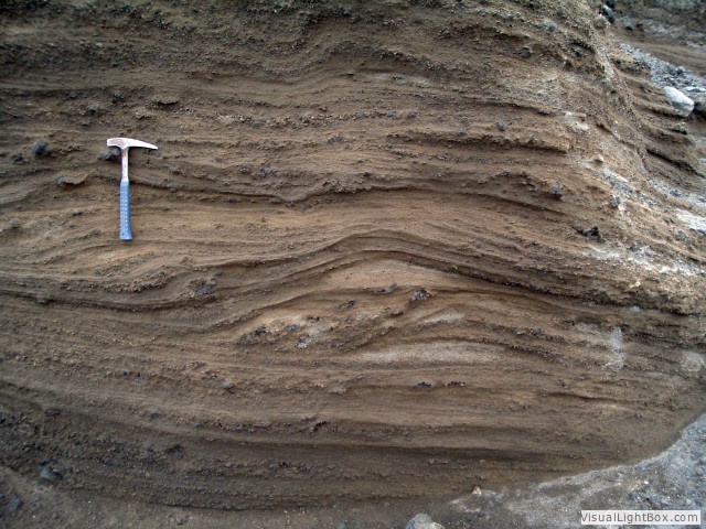
Base surge deposits, Vatnsfell tuff cone
Stampar feeder dike |
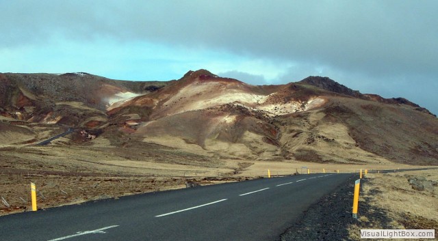
Stop
2: Krysuvik (High
temperature geothermal area)
Continuing to the west on
road no. 425, passing the village Grindavik and follow the
gravel road no. 427 to
Krysuvik.
High temperature geothermal area – High temperature areas
occur only in active volcanic zones and probably mainly where there are
shallow magma chambers or intrusions cooling underneath inactice
volcanic areas. Thus high temperature areas are localised areas of
upward ground water flow in active volcanic areas. There are mainly two
types of edifice in high temperature areas, fumeroles and solfataras.
Solfataras are common in high temperature areas. They contain blue-grey
boiling clay, the colour being due to sulphur compounds of iron which
form when sulphuric acid dissolves the rock, the acid forming when
hydrogen sulphide (H2S) reacts with atmospheric
oxygen. In the solfataras the clay splashes as gas bubbles burst and
the clay builds up a rim around them. The rocks of high temperature
areas are usually greatly altered.
|
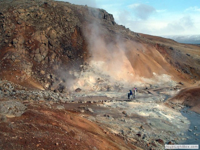
Krysuvik geothermal field
Krysuvik geothermal field |
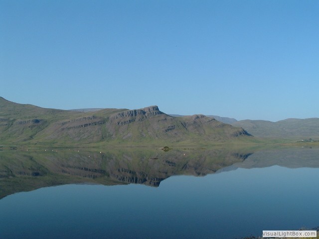
Stop
3: Hvalfjörður (Late glacial and
intrabasaltic sediments, zeolite facies)
Take road no. 1 from Reykjavik
to
the north. Just a few hundret meters before the Havlfjörður
tunnel turn right and take the old ring road (road no. 47).
The
route to Hvalfjörður
from Reykjavík passes below the slopes of Mt. Esja (914 m),
which dominates the horizon north of Reykjavík. Mt. Esja is
the
result of Pliocene-Pleistocene volcanism, and contains basaltic lavas
as well as gabbroic intrusions and rhyolite, numerous basaltic dikes,
clastic (volcanic and glacial) sediments. The Esja succession covers
about 1.3 million years, between 3.1-1.8 million years ago. The
mountain got its present shape as a result of repeated episodes of
glacial erosion during the Pleistocene. The western part of Mt. Esja is
an eroded flank of the Kollafjörður caldera volcano,
which was
active 3-2 million years ago. At the base of the mountain there are
basalts and dolorite dikes, but higher in the strata horizons of
palagonite (formed by supglacial eruptions) and tills appear. The
eastern part of Mt. Esja and
Móskarðshnjúkar
(rhyolite) are the remains of a younger volcanic centre, the Stardalur
central volcano, active after 2 million years ago.
For getting a glimpse of the Pliocene strata can be visit at a section
at the base of Mt. Esja at a site called Kiðafelssá,
where clastic sediments of glacial nature outcrop close to sea level,
and have a discussion on the origin of the sediments. Approximately 120
m of tholeiitic and olivine tholeiitic lavas separate the two earliest
diamictite units in Hvalfjörður. The younger unit
forms an impressive cliff along the coastline of the fjord
Hvalfjörður, and is interpreted as a localized
succession of flow units based on its overall stratigraphic framework
and composition. The diamictite which in places rests on stratified
fine-grained sandstone and conglomerate, displays a facies association
consisting of massive, matrix supported diamictite overlain by clast
supported diamictite intercalated with finer grained waterlain
sediments and sediments of fluvial origin. The overall appearance of
this section suggests continuing sedimentation with occasional
interruption of single lava flows. Pebble fabric from this exposure is
inconsistent and in general shows a unimodal pattern. Post-depositional
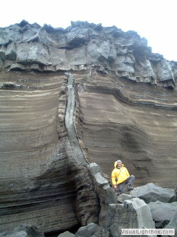
tectonic and igneous activity is indicated by basaltic dykes and mud
dykes that cut through the diamictite (Geirsdóttir, 1991).
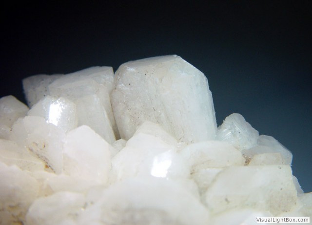
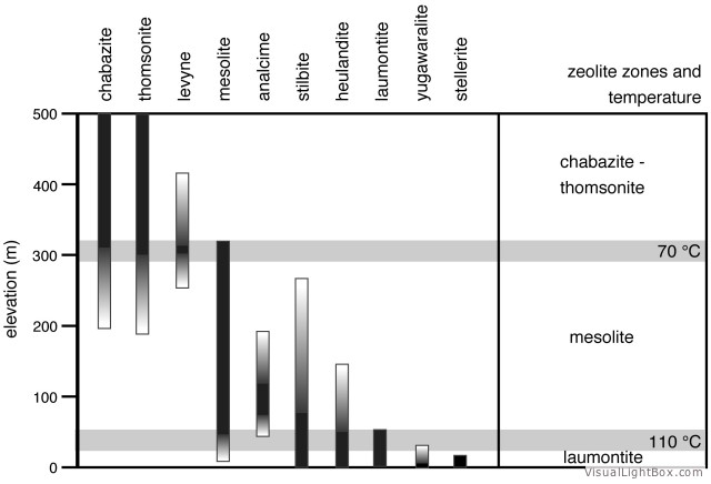
Burial of the lava pile and the higher heat flow through the
hydrothermal activity in relation to central volcanoes have formed
various zeolites, which can easily be collected on the shore line of
the Hvalfjörður. By careful
study of the zeolite variation, zeolite facies zones can be
detected like in Eastern Iceland. Additional dolerites and rhyolites
associated with the central volcanoes can be found around the fjord.
The basalts are affected by progressive low-temperature metamorphism,
caused by the burial of the lava succession and higher heat flow from
nearby central volcanoes. Low-grade zeolite facies metamorphism of
basaltic lavas in the Hvalfjörður
area results in two distinct mineral parageneses that can be correlated
to events in the burial and hydrothermal history of the lava pile.
Stage Ia represents syn-eruptive near surface alteration in which
celadonite and silica were precipitated along primary pores. During
regional burial metamorphism (Stage Ib), hydrolysis of olivine and
glass led to the formation of mixed-layer chlorite/smectite clays. The
chlorite content of stage Ib phyllosilicate vesicle rims increases with
increasing burial depth and temperature. Stage II occurred after burial
and is marked by zeolite mineralization caused by higher heat flow from
the Laxárvogur and Hvalfjörður
central volcanoes. Altogether eleven different zeolites were found in
the Hvalfjördur area: analcime, chabazite, epistilbite,
heulandite, laumontite, levyne, mesolite, stilbite, stellerite,
thomsonite and yugawaralite. In total, three separate depth and
temperature-controlled “zeolite zones” occur in the
Hvalfjörður
area.
|
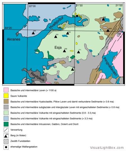
Geological map Hvalfjörður
Basalt steps, dipping in SE direction
Diamictite
Dike
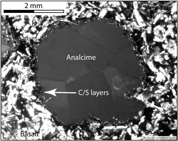
Thin section showing alteration
|
Rhyolite
Analcime
 Stellerite Stellerite
Zeolite facies
|
Stop
4: Þingvellir (Plate boundary,
volcanism and history)
Take road no. 448 from
Hvalfjörður until you reach the crossroad with road
no. 36. Turn to the east and head the þingvelir.
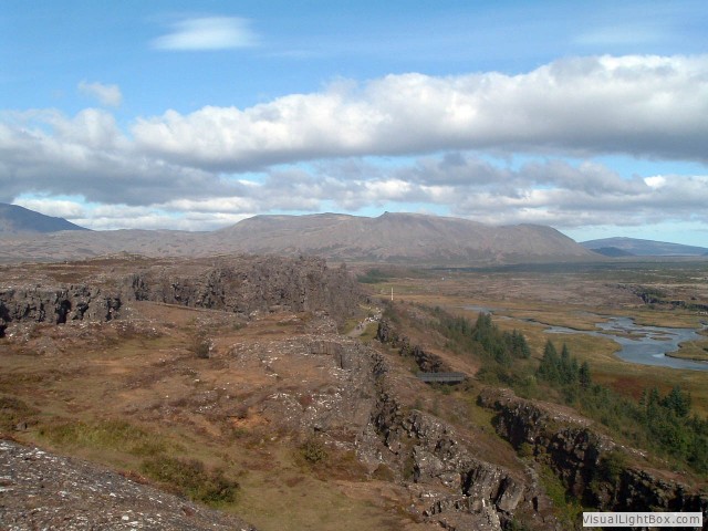
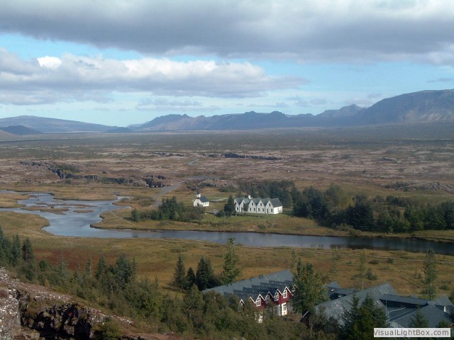
Þingvellir area is a part of the
North Atlantic rift system. It can be described as an area of sea-floor
spreading, displaying the close association of crustal rifting and
volcanism. The rift zone constitutes a graben bounded by major faults.
The rift valley narrows from about 20-25 km in the NE to about 10 km in
the SW. The extension appears as nearly parallel fissures and
down-dropped fault blocks running along the length of the valley. On
the west (North American) side of the valley, the blocks step down
toward the east, while the situation is reversed on the east (European)
side. Thus the valley floor is a linear block that has subsided as the
valley walls were pulled apart by plate motions. The valley walls are
moving apart at a rate of about 7 mm per year, and during the past 9000
years the estimated horizontal extension is of the order of 70 m. The
floor is subsiding at about 1 mm per year, with a total subsidence of
40 m for the past 9000 years. Rifting within the graben is episodical,
with the last major earthquake activity occurring in 1789. During the
1789 earthquakes the graben floor subsidised 1-2 m.
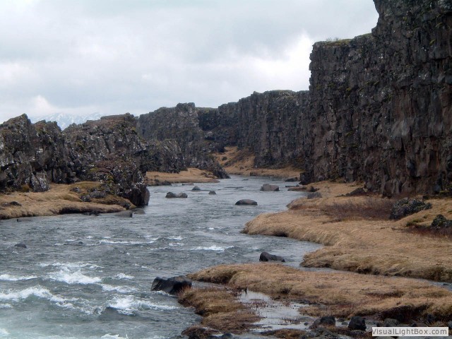
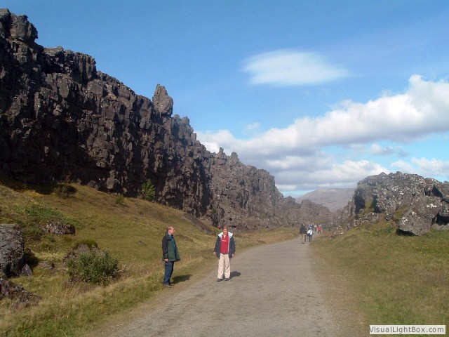
Almannagjá is 7.7 km long. Its greatest width is 64 m, and
its maximum throw is 30-40 m. It marks the eastern boundary of the
North American plate. Its equivalent across the graben, marking the
western boundary of the Eurasian plate is Hrafnagjá. It is
11 km long, 68 m wide and has a maximum throw of 30 m. The
Þingvellir faults are believed to be the surface expressions
of deeply rooted normal faults. The numerous fissures encountered on
the valley floor are of similar origin.
The bedrock of the Þingvallavatn catchment consists mostly of
postglacial lavas that are most extensive in the central part of the
graben and Late Pleistocene pillow lavas and hyaloclastites of
subglacial origin and sub-aerial lavas. The Þingvellir graben
is surrounded by volcanoes, that illustrate the connection between
rifting and volcanism.
The Þingvellir lava (Þingvallahraun) floors the
northern part of Lake Þingvallavatn and the graben floor
north and east of the lake. It originated in a major fissure eruption
to the southeast of Hrafnabjörg, around 9100 years ago. The
many single flows of this lava are best exposed in the fault scarp of
Almannagjá, where numerous sheets of individual lava lobes
have been successfully stacked as the eruption progressed.
Mt. Skjaldbreiður (1060 m) is a huge shield volcano that
dominates the horizon to the north of the Þingvellir graben.
It was formed during a prolonged eruption about 9000 years ago.
|
Þingvellir
Þingvellir
Almannagjá
Almannagjá |
Stop
5: ? (????)
|
